Day
38 – 6 Aug – Roxby Downs.
Its
been nine days since the last post, we've travelled over 500km in
that time, and the problems of securing internet access in remote
Australia are beginning to show. We are passing towns with public
phones, but no mobile phone towers. This is where the difference
between the my old pocketmail service and modern tablets are
beginning to show themselves. The gaps between posts also mean
future posts are going to get a bit epic. I hope this ok.
First, a few clarifications to my previous post.
Riding
north to Hawker we encountered remnants of the old narrow gauge Ghan
railway. I said that Jamestown might have had greater days as a
transfer point for trains heading north-south and east-west. This is
incorrect. The old Ghan and the East-West train met at Peterborough.
I
also noted changes in land use and implied that that Hawker saw a
transition from sheep to cattle grazing. Riding further north that
turned out to also be incorrect. There were plenty of sheep Hawker
district and further north. It is more accurate to say that
somewhere between Jamestown and Hawker farming changes from broadacre
wheat cultivation with sheep to purely sheep grazing country,
Conscious salved, let's return to the narrative.
Day 30 – Wed 29 Jul – Hawker to Wilpena Pound
I've
raved about the beauty of the country we've been riding through until
I feel like I've worn out my stock of superlatives. Its a shame
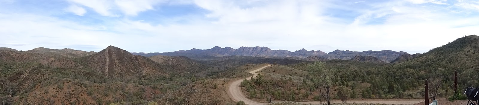
really because in the Flinders Ranges the country is really good.
The land is folded in and eroded by epic forces and the landscapes
are truly awe inspiring. Even the photos don't really do it justice
but they speak better than I. Instead I will reflect on the
differences between riding and driving this country.
As
we rode north of Hawker, riding the undulating road and crossing
frequent dry river beds, we travelled at the speed of the wildlife.
Eagles soared in the skies above, kangaroos bounded alongside and
mobs of emus either wandered past making their deep guttural sounds
indifferent to our passing, or sprinted alongside the road. Riding
is being in country, seeing it at the scale of the things that live
in it, and that experience is worth all the hills and headwinds it
throws at you.
The
contrast with car travel could not be made more apparent as we
entered the Flinders ranges national park and approached Wilpena
Pound. The land becomes more lush, changing from salt bush plains to
an open woodland. The ranges are a good water catchment and support
more life, but unfortunately the last 10km of the road to the pound
was littered with dead things – emus, lizards, birds even a
kangaroo and joey - in various states of desiccation and
decomposition and all showing the tell tale signs of motor vehicle
impact. It was tragic.
There's
something inherent in driving that reduces the world to a
destination, and things that must be avoided on the way to that
point. As humans we perceive, process and react to the a world
travelling less than 40km/h. After all, for the vast majority of
human existence we've only needed to understand a world travelling a
little faster than a run. Travel faster than this and our brains
have to take shortcuts and we miss most of the experience. When that
experience involves a close range animal interaction, most of the
time it does not end well for the critter.
We
arrived at Wilpena Pound in the early afternoon and spent the hours
before sunset near creeks and in the pound (a hollow surrounded by
ridges). I could have spend several days there, and maybe one day I
will. It is easy to see why it it sacred to its traditional owners,
the rock people.
 |
| It can seem a bit empty when viewed from a car windscreen at 100km/h |
 |
| Travel at emu speed and they'll share the journey with you. |
Day
31 – Thu 30 Jul - Wilpena Pound to Middlesight Water Hut
Dismayed
by the roadside carnage, surrounded by National Park and inspired by
the country we decided to get away from the sealed road and return to
the Mawson Trail. The trail followed park maintenance and
fire management tracks and had stout gates to prevent 4WD access.
These tracks were ours to enjoy – if we could handle their
ruggedness. The wind picked up. At times the headwinds were so
strong that it was difficult to hold our bikes upright. The path
became a single track through a forest, and Maree and I got separated
for a short while (cue Cure song). I'd got confused whether she was
ahead of behind me and eventually I caught up. The track crossed
many riverbeds. The rivers were usually in fairly deep channels, so
we did a fair bit of getting off and pushing.
However,
for our efforts we were rewarded with emus. Lots of them just walking
up the road way minding their own business and provided we slowed
down to meet their pace, more than happy to have us fairly close. I
think a close quarter view of an emu is about as close as I'm ever
going to get to meeting a dinosaur. Their feet, their gait, their
size, their stumpy useless forelimbs, even their insulating
flightless feathers mirror the so many of traits of the beasts from
dinosaur books. It was a privilege of share their living space.
We
finished our ride at a hiker's hut on the Heysen Trail. The Heysen
Trail is a massive hike running from Kangaroo Island to Blinman,
something even more challenging the Mawson Trail. The hut gave us a
warm place to stay, far away from caravan campers – a place where
Maree and I could enjoy a magnificent sunset alone. Inside the hut
there was a visitors book. One of the entries was from a pair of
cyclists who had followed all the Mawson Trail. It was day 20 of
their trip. After reading this we felt much better about our
decision to ride using sealed roads and a few highlights of the
trail.
 |
| Did I mention there were a few rough patches on the Mawson Trail? |
 |
| But, the views are worth it. |
 |
| as is the company |
 |
| Views and hills. Yep we had to ride up that gravel track to take this panorama. |
Day
32 – Fri 31 July - Middlesight Water Hut to Parachilna Gorge
The rocks of the Flinders Ranges are a deep red, have a fine grain
and with a little oil make a fine ochre. They also easily split into
layers making them perfect for fossil preservation. Many jellies and
other pre-Cambrian weirdness have been preserved in these rocks –
and whilst I did not find any, there were times where I imagined the
ripple pattern I saw preserved in the rock was the remnant of some
ancient beach.
The trail took us north and eventually joined the sealed road to
Blinman, a former copper mining settlement, now a tourist attraction
as the 'highest town in South Australia'. It's a pub and general
store kind of town, who's principle attraction appears to be that
it's the town at the end of the tar, The walls of the pub are pasted
several centimetres deep with business cards of visitors –
suggesting that for many, simply getting here was some kind of
achievement worth noting by leaving a mark. We resisted the
temptation.
The
road out of town, heading west and back to the main road north, was a
stony gravel track running through Parachilna Gorge. It was steep,
curved and chewed up into brutal corrugations by tourists in 4WDs.
It was mostly down hill, and I let
gravity do the work and had a joyous time doing it. At the bottom of
the hill (and after a long wait) Maree reminded me of the
consequences of a broken spoke so far away from help – and from
then on I've been trying to ride a little cautiously.
 |
| Dawn over the hikers' hut |
 |
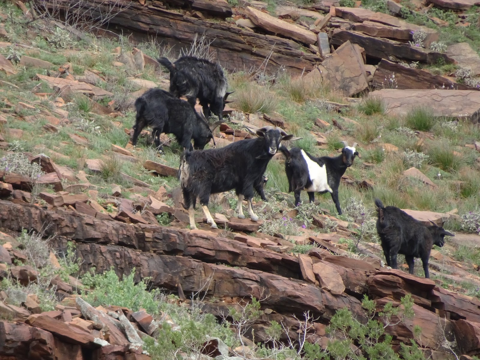
| Goats in the gorge |
 |
| Big - Euro roos too. |
 |
| And the kind of roads that make you question the wisdom of 300km treks on 4WD tracks |
Day
33 – Sat 1 Aug - Parachilna Gorge to Leigh Creek
The
last time I filled up with water was two days ago Wilpena Pound.
There were opportunities to refill at the hut, at Blinman and at our
campsite in Parachilna Gorge
at the start of the Heysen
Trail, but these were all from tank water sources with 'untreated
water' warnings. I had the capacity to reach and expectation I could
refill when we reached Parachilna, the first settlement on the main
road. This was an error of judgement.
Parachilna
wasn't a settlement, it was a pub. A fine looking pub, but a pub
that was not open when we got there. There was no water. The next
town was Leigh Creek 70km north. Not to worry I had more than a litre
of water left. I'll fill there. Then came the headwinds.
I
made it, but it was not fun. I was riding as hard as I could and it
felt like I was getting nowhere. I rationed my water taking small
sips only when I passed the road markers showing the Leigh Creek
getting
closer.
I ran out of water with 10km to go. I kept going, pains in my
throat, straining with aching limbs and sore feet and eventually made
it to the Leigh Creek roadhouse. Destroyed I gladly paid $4.50 for a
600ml of bottled water, and the same again few minutes later for a
Coke. I was wrecked.
Leigh
Creek is a strange place. Built in the 1980s to support a coal mine
supplying a Port Augusta electricity station, the road layout is
weirdly suburban. The school, park and shops are in a central
cluster accessed by curvilinear streets and surrounded by detached
dwellings on cul-de-sacs. It's very different to the railway era
grid towns we've been passing through till now. The overall effect
is one of a people denying they are in fact, in the middle of the
outback. It feels more like Craigieburn.
Following
our water scare, and the difficulty riding the Parachilna
Gorge road, we reviewed our plans. Our first plan was to ride along
the Oodnadatta Track from Marree to Coober Pedy a distance of around
380km on a 4WD track with William Creek (a one person town) our only
possible water stop. After our day battling headwinds on short water
rations, this plan lost its lustre, with the longer Marree, Roxby
Downs, Woomera Coober Pedy route became more appealing.
Whilst
camped at the Leigh Creek Caravan park, we saw a bus load of
'adventure' tourists. It has been a motto of mine (ever since I read
it in a Douglas Copland novel) that 'Adventure is never found on the
back of a bus'. They were having a good time and provided they
stick to themselves they are welcome to it. To avoid questions we
snuck away from the caravan park as soon as our tent was up, found a
spot in the spinifex to watch the sunset, then ordered dinner at the
Leigh Creek pub, only returning to the caravan park when the
adventure bus tourists were either asleep or crowded around their
camp fire paying no head to the outside world.
 |
| Into the headwind |
 |
| Rail gang settlement on the Ghan |
Day
34 – Sun 2 Aug - Leigh Creek to outside Marree
Weather
gods be praised, today we had a tailwind – and my were we happy.
We revelled in a wind which allowed us to sit on 30+ km/h for most of
the day, even as the sealed road gave way to gravel.
Our
breakfast stop was Copley, a tiny settlement 6km north of Leigh Creek
where an enthusiastic cafe owner served us bacon and eggs and told us
of the roads ahead. Apparently they are in the best condition we can
expect. There were floods a month ago and the roads were recently
graded. This was good news, but didn't change our plans – we were
taking the long way with more service stops – via Roxby.
As
we continued we passed more ruins. These were settlements for the
maintenance crews for the narrow gauge Ghan railway. They occur
every 10mi of railway and the people who once lived there were
responsible for their making sure the train go through their patch of
rail – which in given the periodic flooding meant reconstructing
the railway every once in a while. Keeping the Ghan open involved a
significant commitment in staff and money – a commitment
Commonwealth governments were once prepared to make.
We
pass a ruined rail gang settlement as we ride pass the Leigh Creek
coal mine. The mine closes in 2018. Nobody wants their coal now
that the Port Augusta power station has closed. The mine and
probably much of the Leigh Creek township will follow the rail gang
settlement into ruin.
Speeding
on we arrive at a Roadhouse and pub called Lyndhurst. Several horses
wander by nibbling on the salt bush doing their horsey thing. They
seem oddly out of place. We buy a couple of salad rolls for lunch
and push on.
After
Lyndhurst the road becomes a patchy mix of bitumen and gravel, the
wind pushes us a long, but it also kicks up dust and soon we are
riding in a dust cloud and I'm reminded of Mad Max Fury Road. Its
an eerie experience being surrounded by a beige sky and not really
having any horizon. We are in remote country now.
We
ride more than 100km and could have quite easily ridden into Marree,
but it being Sunday, us looking to avoid caravan park questions –
we chose to camp 5km out. This way we can arrive early on Monday, do
a shop and then ride on. We camp among the salt bush and can see the
lights of Marree on the horizon. Our reality is becoming a
cinematographer's dream.
 |
| An abandoned house, and soon to be abandoned coal mine |
 |
| Dusty Tracks |
 |
| and spectacular sunsets |
Day
35 – Mon 3 Aug - Marree and Oodnadatta Track
Marree
was once an important rail head. Three diesel locomotives are parked
in the centre of town and
are a reminder of the days
when herds of cattle driven down the Birdsville Track were were
loaded onto rail cars and sent to market. Today, its a place where
convoy groups of four wheel drive tourists make their last supply
stop before heading into the desert.
We
stock up at the general store. Our last major supply shop was
Hawker, and we feel we are running low. It is a small shop, but has
a big price tag. Maree buys a hedgehog slice for later, and it is
fantastic. It has a layer of mint, and we finally eat it we rave
about it – joking that a dedicated boyfriend would be prepared to
ride to the shops – that shop – to get their girlfriend a
hedgehog if they asked for it.
We
head out on the Oodnadatta Track a little after 10. Our route
involves a 65km section of the track before we head south. The track
is corrugated but the biggest challenge are the four wheel drives
convoys – groups of three vehicles who pass way too fast, kicking
up dust and stones as they pass. I ride ahead, and take a rest stop
at a Ghan steam train water tower. As I look up at the rusted tank a
kestrel pops over the edge of the tank and hovers directly above me.
The bird is three or four metres above me flapping madly but
stationary in the air. It then soars off in search of more
interesting prey leaving me completely amazed.
We
are near Lake Eyre, and pass briny creeks and salt flats. This arid
country has an otherworldly look and we too are looking different to
our city selves. It's been eight days since my last shave (or shower
for that matter) and I have ridden in and slept in the same clothes
all that time. My scarf has picked up a red dust hue and it is
fraying. If this is Mad Max country, I look the part. I have become
a warrior of the wasteland.
We
find the Borefield Track, our road south to Roxby Downs in the late
afternoon. It is quiet compared to the the Oodnadatta Track. This
road is a functional mine access track, not some challenge for the
four wheel drive set. We camp and marvel at a sunset and colours
that fill both horizons. After the sun goes down the sky changes
hue, first rich oranges and reds then deep blues and purples until it
the first stars appear.
 |
| Is this the end of the line for Commonwealth Railways? Marree |
 |
| 4WD suspension turns the track into washboards. |
 |
| Decisions, Decisions - we head south. |
Day
36 – Tue 4 Aug – Borefield Track
The
northern end of the Borefield Track is stony, firm and in better
condition than the Oodnadatta Track. Unfortunately, as we we head
south it becomes sandy – and sandy tracks are a bastard to ride on.
The bike slips out from under you and staying upright becomes a
constant challenge. The sand occurs in small drifts among the stony
track, so navigating it is tough work.
The
road was tough of the bike kit too. The constant bumps riding over
the rocky track knocked my tent out of its position and it fell on
the ground only to be dragged tens of metres before I realised what
had happened. The road wore a hole in the outer storage bag but
thankfully no further. That problem was easily fixed with gaffer
tape. Later on a bolt fell out of one of my panniers. It supports
the front rack mount. Again gaffer tape to the rescue. I hope it
will hold for the rest of the journey.
I
had hoped to ride 110km and make it into Roxby Downs. I rode hard.
Maree took a more sensible pace. Toward the end of the day we passed
a large fenced area – a wildlife reservation that formed part of
the Olympic Dam mine, an offset area designed to smooth over the
approvals process and take placate those with environmental
objections to uranium mining.
We
encounter the 'Arid Recovery' area in the late afternoon. I was
confident we could make town, Maree was equally sure that it was
still too far away. Either way, she recognised the fence for what
it was, the start of mining company managed land, and thus the end of
opportunities for sneaky bush camp. I was several hundred metres
ahead when I encountered the fence and rode on.
Maree
was livid when I finally stopped for a rest and wait for her to catch
up. It was approaching 5pm, less than an hour before sunset and I'd
left our last possible camp site several kilometres back – and were
roughly 20km out of town. After the offset area, was the mining
lease proper – complete with dire warning signs about trespassing
on an active mine site. I'd stuffed up, and our only option was to
backtrack. There's something particularly awful about riding back
down a tough gravel road. It was hard to ride down, it is equally
hard to ride back and you know you'll have to ride it again tomorrow.
There are responsibilities that come with riding on ahead, and I'd
stuffed up.
 |
| When fences appear stop and discuss options. |
Day
37 – Wed 5 Aug - Roxby Downs
We
started the day camped in salt bush country on fine desert sand,
slept in bivvy bags and were awakened by birds tweeting at the dawn,
three days down rough gravel tracks away from anything resembling a
town. By midday we were sitting in a shopping mall car park watching
young mothers load their SUVs with a the week's groceries. The
contrast was made all the more extreme by the local radio station ROX
FM playing 'The Carpenters' on public address as we rolled down the
main drag. These mining towns do their very best to bring suburban
life into remote country. I'm not sure I like it. It feels weird –
David Lynch weird.